 |
|
About the area
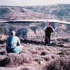
North launch
|
Dora village sits atop a ridge that overlooks a wide valley formed
by the Diarizos river. This valley is one of several fairly deep and wide
drainages radiating from the mountains to the coastal plain in southwest
Cyprus. The river plain is fairly wide and open and a number of suitable
landing opportunities exist. The river itself is a seasonal stream, dry
during the hottest months.
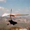
This is a beautiful valley over which to fly. Altitude gains can be good and cross-country is possible when the inversion relents. On a light, unstable day one can fly all over the valley, which is expansive, and share the air with the Griffen vultures that frequently cruise the area. Cloud base is usually between 2000' and 4000' above launch, though in summer an inversion usually restricts altitudes to less than this and strong, blue thermals are the rule. On north-easterly wind days (usually during the winter months) we have found that a wave may set up above and roughly parallel to the western side of the river plain. The sea breeze plays a major part in the flying conditions of this area. Except in winter it is fairly reliable on a daily basis, though it's intensity and arrival time may vary from day to day. When it is light, thermal soaring can be quite good. When it strengthens it breaks up thermals and dramatically increases their drift. This reduces our flying to ridge soaring in bumpy air. Summer evenings, as the sea breeze relents, the heated valley can produce some wonderfully smooth and pleasant flights. Normally, when using the north or west launches, we land in fields on the river plain about half a mile upstream from the village of Kidasi. As we descend to the level of the lower cliffs, about 400' or 500' above the actual river bed, and downwards to the ground we encounter an area of general turbulence due to upstream airflow (valley venturi) colliding with convection. Thermals are strong but disorganized here. A permanent windsock has been erected at our most used landing field just downstream from a large quarry that is visible from both north and west launches. Landing fields for the south launch lie a few miles downstream near a village called Prastio on the map. We currently use three launch sites in this area. |
|
NORTH LAUNCH
|
|
|
Direction
Launch
Vertical to LZ
Emergency LZ Top landing |
South-easterly
Steep, some bushes below 1300 feet Some small fields below launch can be used Can be top landed nearby |
Getting there
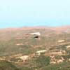
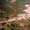
North launch 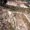
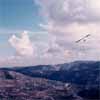
Aerial view N launch |
The north launch lies northwest of Dora village just off the main road
as it crests at the north end of a mile wide bowl. The slopes here are
terraced and cultivated, largely with grapevines, before plunging through
a ravine or over cliffs to the river plain nearly 1300 feet below. It faces
southwest and catches the prevailing breezes coming up the valley from
the coast. This is a good thermal soaring site in light winds and is ridge
soarable when the winds increase. In the latter case thermals may
make the air rather turbulent without providing much height gain.
The generally chosen landing fields lie at the bottom of the river plain in the vicinity of a large quarry, which is visible from launch. It is a fairly long glide and we recommend that you don't allow yourself to get too low in the launch area before heading out. But the glide to the quarry area is a crosswind and downwind glide, which makes it easier. Follow the spine from launch to the right and down (westward). On the way down there are opportunities to recover altitude along this ridge and especially in the vicinity of the goat pens just before the lower cliffs. The lower cliffs can pretty much be regarded as your last chance to save your flight. Once at the cliffs, turn downwind (upstream) and fly over to the quarry area. The quarry itself rises about 60 feet above the bottom and is two very large, flat areas dug into the hillside. When unobstructed, these areas provide a very pleasant landing zone. Frequently, though, the people mining this area fill it with piles of dirt in preparation for removing the dirt (this fine, powdery soil is used in paint manufacturing). These mounds are soft, but the ups and downs are a problem if your flare isn't good. In the area of this quarry, on the river plain itself, there are a number of fields and a dirt road that make nice landing zones. But beware. The river plain is very thermic. In light winds it is switchy and on stronger days it can be just plain turbulent. Note, though, that the quarry is usually less turbulent and we recommend landing there whenever possible. |
|
WEST LAUNCH
|
|
|
Direction
Launch
Vertical to LZ
|
South-easterly
Steep, some bushes below 1000 feet |
 Main LZ's
|
The west launch lies completely across the river valley at the top
of a bowl that rises behind the aforementioned quarry. It is easily
seen directly past the quarry as viewed from the north launch. Reach it
by taking a dirt track from just downstream of the bridge below the landing
fields below the quarry, which we also use for this launch. It is
a
good alternative when northeast winds blow over the island. Such winds tend to bend around the island and be more easterly to south-easterly in this area. The air here will be rowdy on a good, convective day. Watch for crosswinds at launch, though, which will generally be from the right as winds begin to flow up the valley. On north-easterly wind days one can thermal up in the bowl to about 1000' or more over launch and then slide over toward Kidasi where wave might be found. |
|
SOUTH LAUNCH
|
|
|
Direction
Launch
Vertical to LZ
Emergency LZ
|
North-westerly
Primitive slot with hazards About 1400 feet Some fields on a plateau just beneath launch |
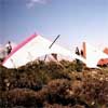
West launch rigging area |
The south launch lies southwest of Dora village, at the south end of
the bowl. Get there by driving from Dora village south toward Kouklia.
You will reach a pass at the south end of the Dora bowl and two dirt roads
will go off to the right, pretty much at the same place. One goes down,
the other goes up. Take the one that goes up to get to launch. The other
goes to the LZ area. The slot isn't cleared as much as it ought to be.
It can be considered a bit unsafe until more brush is cleared away.
Use it at your own
discretion. In strong northwest winds there may be quite a lot of turbulence as the ridge on the opposite side of the river plain is higher. The LZ for this launch lies directly out from the launch on the river plain where a low, concrete bridge can be seen crossing the river. Beware of thistles and melon-sized river stones. We would strongly recommend scouting the area and strategic placement of a windsock. |
|
|
 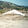 
Main LZ |