
Rough, shallow slot with steep drop-off
1800 feet
Area behind Germasoyia reservoir
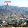
View of entire valley area
Reservoir. The mountain is dotted with pines and overlooks the greater Limassol area and out to sea. It is a wonderful place to fly, with strong, tight thermals on an average day booming up from the heated rock below. The valley is large and makes a beautiful flying arena.
Launch is directly below an observation shelter that is visible from Finikaria village, below by the lake. It is a bit rough, somewhat shallow, and is very unforgiving of bad judgement of conditions. Winds coming up ravines on both right and left of launch may cause tricky conditions. We recommend liberal use of streamers. With good judgement, however, this launch is very easy to use.
Between launch and the LZ the terrain is steep, rocky and hostile. We definitely do not recommend getting low in the ravine in front of launch. If we don't get immediate lift we head to the ridge across the ravine, on a direct line from launch to LZ. Once we have reached this spine we breathe easier. We usually follow the east side of the spine, both to take advantage of thermals there and to stay out of any venturi that may exist in the river canyon. We recommend that pilots new to the site fly with someone familiar to the site, at least for the first time.
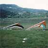
Kiparisha LZ
Getting to launch is a bit more difficult. The last mile is pretty much a 4WD track, though those who care not for their wheels have made it without losing too many bits from the undercarriage. From the LZ, take the road that goes up the hill (a right turn when coming from Finikaria) and follow it about 1.6 km to a crossroads. (Don't take any tracks going off to the left until you reach this crossroads).
Turn left and follow this road to and then up the mountain. It will curve around to the right and begin the climb. The road winds around quite a bit as it climbs up the back side of the mountain. You will see two turnoffs to the right that are marked by signs to Pereklisha as you climb. Shortly after the second Pereklisha turnoff, and about 9.4 km. from the crossroads, you will find a left turn that goes up the mountain and is marked by a forest service sign "Kiparisha". Take this left and follow it up. 1.1 km. later you will find a little mini shelter on your left and a park bench on your right. Continue up the road another 2.1 km. to another crossroads with a park bench on your left. At this point the 4WD stuff begins. Turn hard right and go up a rather rough, stoney stretch for about 50 feet, then continue on that road to the summit. You will be able to see the observation gazebo as you approach. Make sure that you don't block the road when you park because people do drive up there from time to time.